


Guests
- Seán Kinanenews and public affairs director at community radio station WMNF in Tampa, Florida.
- Harold Wanlessprofessor in geography and urban sustainability at the University of Miami.
Authorities say hundreds may be dead after Hurricane Ian made landfall Wednesday along Florida’s southwestern coast as a powerful Category 4 storm, one of the strongest hurricanes ever to hit the continental United States. We get an update from Tampa and look at links between the climate crisis, rising sea levels and intensifying storms. “It’s just been devastating, and we don’t know the full extent of the damage yet,” reports Seán Kinane, WMNF news and public affairs director. “We are seeing these storms that aren’t otherwise stressed just exploding in intensity,” says Harold Wanless, professor in geography and urban sustainability at the University of Miami.
Related Story
Transcript
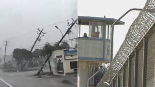
AMY GOODMAN: We begin today’s show in Florida, where authorities say hundreds may be dead after Hurricane Ian made landfall Wednesday along the state’s southwestern coast as a powerful Category 4 storm, one of the strongest hurricanes ever to hit the area. Ian was about 500 miles wide when it crashed into Florida with a 30-foot-wide eye wall and hurricane-force winds that extended 40 miles from the center. Satellite images show the storm engulfing the entire state. High winds and storm surges devastated coastal communities. Some storm surges were 12 feet high. Some cities saw more than a foot of rainfall. More than two-and-a-half million have lost power as we broadcast. Many are also without water. Rescue teams are working in the dangerous conditions to find people trapped in their homes.
Earlier this morning, the sheriff of Lee County, Florida, Carmine Marceno, spoke by phone to ABC’s Good Morning America.
SHERIFF CARMINE MARCENO: While I don’t have confirmed numbers, I definitely know the fatalities are in the hundreds. There are thousands of people that are waiting to be rescued. And again, cannot give a true assessment until we’re actually on scene assessing each scene, and we can’t access people. That’s the problem.
GEORGE STEPHANOPOULOS: Fatalities in the hundreds?
SHERIFF CARMINE MARCENO: So far, confirmed in the hundreds, meaning that we are responding to events, drownings. And again, unsure of the exact details, because we are just starting to scratch the surface on this assessment. We’re doing everything that we possibly can. Again, now it’s to protect and preserve lives, and we are in full force doing that.
AMY GOODMAN: That’s Lee County, Florida, Sheriff Carmine Marceno being interviewed by George Stephanopoulos on ABC’s Good Morning America.
Hurricane Ian has now weakened to a tropical storm, is dumping torrential rains as it heads toward Georgia, Virginia, North Carolina and South Carolina, after leaving a path of catastrophic damage.
For more, we go to Tampa, Florida, for an update from Seán Kinane, news and public affairs director at community radio station WMNF.
Seán, you are hunkered down there at WMNF. Your building is built to withstand a Category 5 storm. I have visited it repeatedly. It was in the track of Ian originally, but ultimately the storm hit south of you. You’re staying there, because you live on an island where you could not go back. Welcome back to Democracy Now! Give us the latest as you serve the community with information.
SEÁN KINANE: Thank you, Amy.
Yes, in Tampa, I am in a building that can withstand a Category 5 hurricane, but, lucky for the people of the Tampa Bay area, that’s not what struck here. We were — we were spared.
But the most important story right now is what’s happening down in Southwest Florida, as you heard from the sheriff of Lee County, where hundreds of people are confirmed dead from this storm, with the unbelievable storm surge that came through, several feet of water in major cities in Southwest Florida, like Naples and Fort Myers. It’s just been devastating. And we don’t know the full extent of the damage yet, because it’s just now daylight, and it’s just now safe enough, perhaps, to go outside for people and for these emergency crews to go out and assess the damages.
NERMEEN SHAIKH: Seán, could you talk a little bit more about where these fatalities — if there’s been any talk of where the most facilities occurred, and also if there’s any word on when power might be restored, two-and-a-half million people now without electricity?
SEÁN KINANE: Yeah, so, I don’t know that much first-hand about the fatalities. All I know is what I’m hearing from the Lee County sheriff. And just to give people a perspective of where that is, that’s — the largest city in Lee County is Fort Myers. And that’s right where the storm came ashore. There’s two barrier islands that it struck, Captiva and Sanibel, on the way in, and also Cayo Costa. So, it struck these barrier islands first and went ashore in Lee County. So, there is, of course, going to be the most casualties there, perhaps, but there’s been very strong rains and storm surges all along the coast, from Naples all the way up to almost to Sarasota, so perhaps there could be some there. I don’t have any knowledge about that. But now we’re also worried about river flooding inland. And, you know, some of these rivers are going to be flooding for days and days from now because of how much rain has been accumulating upstream.
AMY GOODMAN: I want to bring in Dr. Harold Wanless. And, Seán, I’m going to ask you to stay with us. I hope you don’t have to get off since you’re on the air constantly. But Dr. Harold Wanless is a professor of geography and urban sustainability. Hurricane Ian is the 121st hurricane to hit Florida since 1851, which has faced more hurricanes than any other state, millions of residents living along its coastlines. The storm first hit Cuba as a Category 1 storm, before it intensified to Category 4, near 5, when it made landfall in Florida. So we want to talk more about the rapid intensification of these storms and the sea level rise that’s already occurred along Florida and how that’s affecting the storm’s impact.
We go to Coral Gables, where we’re joined by Dr. Harold Wanless, a professor in geography and urban sustainability at the University of Miami. He is on the board of directors of The CLEO Institute, a nonprofit dedicated to climate crisis education and advocacy.
So, you’re in Coral Gables. If you can talk about everything you’re seeing in Florida now and where the climate or global heating plays such a key role?
HAROLD WANLESS: Well, thank you for having me, Amy.
Yes, one of the things we’ve been seeing, and it certainly was true with Ian, is that when the wind shear is down, the water is warm, and the ocean water is getting much warmer because of climate change, we are seeing these storms that aren’t otherwise stressed just exploding in intensity. And this was forecast by the hurricane folk, and it’s exactly what’s happening again and again. And we watched this one as it left Cuba just explode into this Category 4 storm. And that is in large part because of the warming ocean. And the Caribbean Sea in the southern Gulf of Mexico was extremely warm for this time of year, and that really drove it.
The other thing that we’ve seen with many storms, maybe only a little bit with this one, is that the steering currents tend to be weaker, so they tend to slow down and hang around, where — the one that hit Houston a few years ago was a good example of that. And they end up just maybe not being a windstorm at the end, but dumping huge amounts of rain. And that sort of happened here. We slowed down as we moved on to Florida, and the rain around Orlando and south has been — will be catastrophic.
One thing about this storm is, the places that were really hit were these very low barrier islands of Sanibel and Captiva and Cayo Costa. These are extremely low and vulnerable. We haven’t really heard much of anything from them yet, and they got the main onshore surge. We saw pictures yesterday about — of Naples, with the water coming in, and on Marco, which were well south of the main push. And we saw some of Fort Myers Beach. But those outer barrier islands were just right in the path of the big eye wall onshore surge, and that’s going to be a huge problem for those islands. It’s going to be tragic when we see the evidence of what’s happened there.
NERMEEN SHAIKH: And could you elaborate? I mean, even though Hurricane Ian was downgraded to a tropical storm, what do you expect to unfold in the next few days in the worst-hit areas in Florida?
HAROLD WANLESS: Well, and it’s not just Florida anymore. There’s a state of emergency on up the coast, all the way to Virginia now, and because it’s exiting Florida now with 65-mile-an-hour winds still. So it’s prime, [inaudible] over the Gulf Stream, which is, again, warm water — it’s prime to just reform as some level of hurricane. And then it will — you know, it’s just drawing in huge amounts of moisture. So, that’s going to be extreme.
The problem with all the rain we’ve had in Florida — and I don’t know the final numbers for the middle of the state, but we’re only — most of the state is less than 100 feet in elevation. A little bit is higher inland, though. And so, there’s really no big slope for the water to pour off of, which means you’re not going to have these catastrophic floods coming out of intense floods out of the rivers. But the water is going to stay flooding for days and days and days in many of these intense rainfall areas. So, that’s a second whammy.
And as this water is draining back into the Fort Myers area from the rivers there, it’s going to make it slower for even the storm surge to come back down. This was a fairly — it had an angle where the storm was moving up the coast rather than straight into it, and that meant that the storm surge could move, push in for hours and hours. And we saw that yesterday. When Andrew hit Miami-Dade County in '92, the storm surge probably lasted about 10 or 15 minutes. It was a fast-moving storm, moving straight in. And so it was in and out, and that's it. But this was a huge penetration of a storm surge.
AMY GOODMAN: Dr. Wanless, at this time, when everyone is paying attention — you know, and you can only imagine what Pakistan is like, when you have a third of the entire country underwater. This is a very close-up look at what this feels like here in the United States. But this time when everyone is paying attention, it seems it’s critical to talk about precisely what you’re talking about: how global heating plays a role in this. And yet you have, like, the director of the National Weather Service saying on CNN, you know, you can never predict if a hurricane is caused by climate change, any one particular hurricane. While that may be true, the bigger point he’s making is: Who knows if it’s the climate crisis? You make a very different point, especially when you’re talking about sea level rise.
HAROLD WANLESS: Well, and because of changing speed of the Gulf Stream, all around South Florida — we’re on the left side of the Gulf Stream in the Florida current — we’ve had, since 1930, about a foot of sea level rise. So, an equivalent storm 90 years ago would have been dealing with a land that was a foot more out of water.
So, it’s not that climate change may be something that will happen. We have warmed the ocean. That is putting more moisture into the atmosphere. We have expanded the ocean because of this warming, and that has raised sea level rise. We are melting ice from Greenland and Antarctica at an accelerating pace. That is going to, in the next few decades, make quite dramatic influence on our present sea level rise, very dramatic change. And all these things are playing a role.
The other thing, when you just want to talk about all the rain, whether it’s a hurricane or just rain storms or even snow storms on land, as the atmosphere warms, it holds more moisture as water vapor, and as it moves on — over the ocean. As it moves on land and cools down, it makes these heavier rains that we’re seeing more and more of, and even heavier snowfalls during the winter. And so, this increase in severe flooding is not just along the coast from hurricanes, but it’s also from storms where the atmosphere has moved from the ocean, water-laden, onto through the land and is creating these intense precipitation events that are causing many of the floods we’ve seen in the last few years. These are increasing.
All these are realities. Everything I’ve said is a reality of global warming, because we have put more carbon dioxide and other greenhouse gases into the atmosphere. You were just talking about the importance of methane, too, another powerful greenhouse gas. So, these things are increasing everything, from a warming atmosphere to a warming ocean to a melting of ice to increasing precipitation over land. And —
NERMEEN SHAIKH: And given that, how much has development along these coastal areas changed to make buildings more secure and able to withstand the effects of these increasing number of extreme weather events?
AMY GOODMAN: And should there be so much development?
HAROLD WANLESS: Well, you could ask, “Should there be so many people?” I guess, along with that. But, you know, there are four times the number of people as when I was born in 1942 on Earth? That’s amazing.
And we’re expanding out into places. Most of our new development on barrier islands is places that we felt were too low or too vulnerable or too narrow. And now if people want to live there, that’s what’s left. And there’s so many examples where you look at it, and you say, “That looks very risky.” But we’re doing it. And we do it with houses, and then suddenly they turn into high-rise condominiums that are also extremely vulnerable. And as sea level rises, and the shore wants to retreat landward, those are going to be left out in the ocean. And that will happen soon. You know, within the next few decades, we’re really going to see that.
Orrin Pilkey at Duke says, for every foot of sea level rise on a coast like the Gulf or the Atlantic, we should have 1,000 to 2,000 feet of landward retreat up the coast, as the ocean and available beach sand reequilibrate. And, you know, we’ve just had this rise of sea level, and we’re now trying to equilibrate with that. But we’re having more rise in the future because of accelerating ice melt.
AMY GOODMAN: Dr. Harold Wanless, we want to thank you for being with us, professor in geography and urban sustainability at the University of Miami. Seán Kinane, this is what you do every day at WMNF in Tampa, bringing out this kind of information. Your final comments as you live and broadcast from the station right now in the midst of the storm?
SEÁN KINANE: Yeah. So, Amy, what I would say to Dr. Wanless’s point about the barrier islands and how dangerous it is for people to be building there and to be living there, just to give an example, the Sanibel Island Causeway, the Sanibel Causeway, was completely wiped away in this storm. We’ve seen pictures of this bridge. This is the only road from the mainland to Sanibel Island and Captiva Island. It’s been wiped away. So, how do you get rescue supplies to these people? How do people evacuate if they didn’t evacuate already? And, you know, this is just a very powerful storm, and we really don’t know what to expect next, as cleanup crews are just now going out to look at things.
And to answer Nermeen’s question from earlier — she was asking when will power be restored to these people. We don’t know, but we did hear from Duke Energy Florida, who said that they have to wait until the wind dies down in order to go out and restore the power to these people. That might be this afternoon in Pinellas County, which is near St. Petersburg, which is what they said. But who knows how long that is in Orlando or in Cocoa Beach or places where the wind is still howling?
AMY GOODMAN: Well, Seán Kinane, we want to thank you for being with us, news and public affairs director at community radio station WMNF in Tampa, Florida.

Media Options